![]()
The Little Cyclades
Mikrés Kykládes The Back IslandsBy Marc Dubin
Intrigued by this intimation of primitivity, Id always wanted to visit, but I only got around to it in 2010 long after the golden years for this little group, according to aficionados, many of whom first arrived back in the oil-lamp days. But at least that means what youre reading is far more up-to-date than anything in a guidebook, or another website for that matter. |
|
|
|
|
|
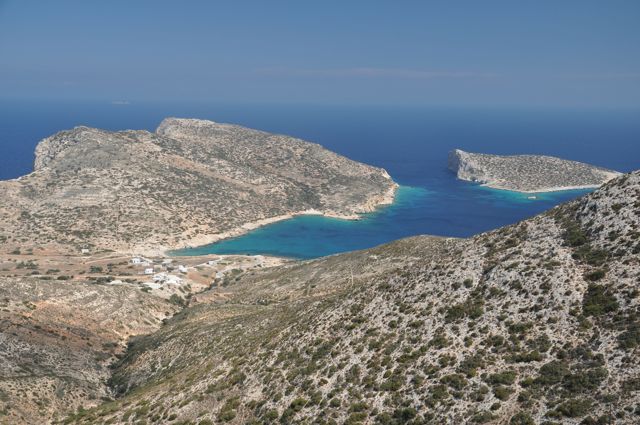
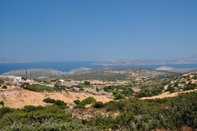
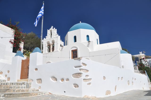
DONOUSSA Lonely Donoussa, second largest of the quartet, possesses exceptionally dramatic coastal scenery once youre away from the port. Besides two Caribbean-standard beaches (with tamarisks standing in for palm trees), there are good walking opportunities a virtue of necessity, as there are no scooters for rent but there is abus service. (The hopeful guy with bikes couldnt get a permit to keep petrol in jerry cans). The hiking should be great, better than Irakliás, but the islanders drove away their faithful walking clientele in 1998 by bulldozing the spectacular cobbled kalderími between Stavrós port and Mersíni hamlet to build the new main road, and damaging the old path from Stavrós to the other hamlet of Kalotarítissa with a pointless, now-unusable jeep track, a textbook example of wasted EU funds.
|
|
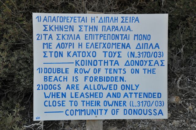
BEACHES
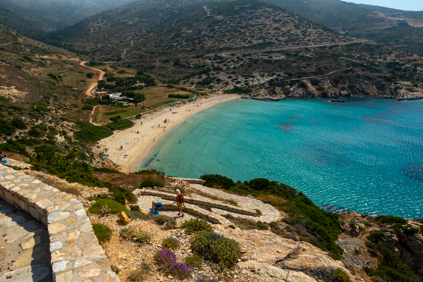
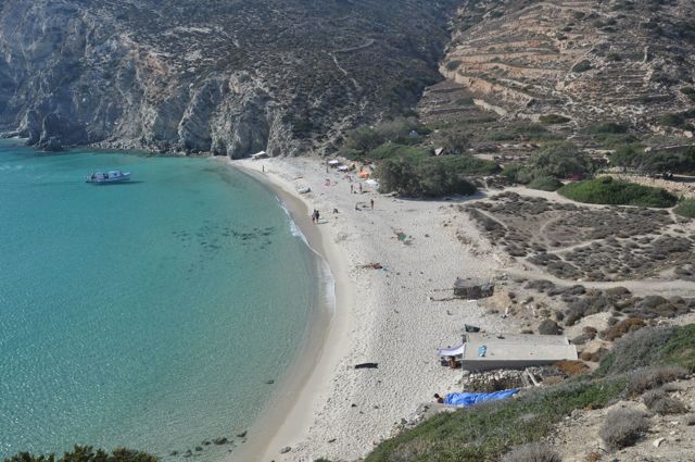
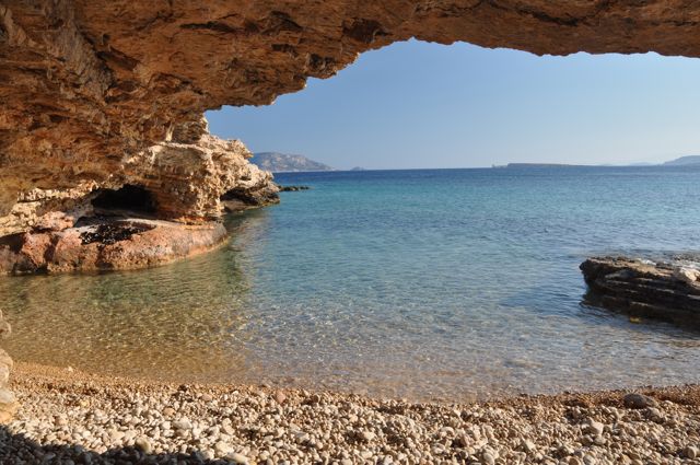
Some 25 minutes walk east of Stavrós, beyond the helipad peninsula, lies Kédros bay, 150m of blonde, fluffy sand, beloved of naturists and free campers alike mostly Italians and Greeks, plus a few Scandanavians or Brits. Tents up to 200 of them in August are no longer allowed on the beach but are required to be in the scrublands beyondthe stone fence separating the beach from the snack barcafé here, adequate for salads, sandwiches and a daily special. At mid-bay in shallow water lies a wrecked World War II boat (German), though little remains of it other than some ribbing. Kédros only rival, an hours walk east, is Livádi, fractionally bigger and more dramatically set, with the same fine sand but no facilities apart from five disused boat-houses, squatted by nudists and free campers who muster up to 70 tents in the vegetation just inland. Civilisation is 20 minutes uphill from Kédros in Mersíni, whose houses cling for dear life to a steep slope, staring out to Amorgós on the horizon and free-ranging chickens far outnumber the 15 resident people. Mersínis raison dêtre and the campers source of water is a flowing spring just below, amidst a conspicuous oasis of plane trees, calamus reeds and orchards. The old laundry trough now has carp in it, and a festival takes place here each September 17, after liturgy at Agía Sofía church. |
|
WALKING ON DONOUSSA
To continue southeast around the island perimeter, follow the dirt track from the southernmost cove 15 minutes to an oasis-with-well (potable, retrievable by bucket-on-a-rope) and the start of a stone-paved path remnant which climbs to the Kalotarítissa-Mersíni road. After a few minutes theres another stretch of old path on the right, but sadly youre forced onto the asphalt again about 45 minutes from the start, and must stay there for the 25 minutes more to Mersíni. |
|
From Kédros you can also walk most of the way to Mersíni without hardly touching the road, using secondary paths and stretches of the old kalderími that werent destroyed in 1998. Follow the dirt access drive inland to the paved road, and just past the gully bridge pick up the path signposted unless someones knocked markers down to largely desolate Messariá hamlet. This is reached after some 35 minutes climbing, but sadly the onward path has been cut and one must descend to the road for a while before bearing down and right onto path resumption between the sharp ravine curve and a lone farmhouse. Once past a well and clump of trees, use old path extents to avoid being pushed up onto the road, forcing your way around wire-mesh fencing, to arrive at the car park by Agía Sofía chapel on the outskirts of Mersíni some 40 minutes beyond Messariá. All this is set to be properly waymarked and cleaned up in the near future. For Hotels in Donousa see Booking.com's Donousa Page |
|
|
|
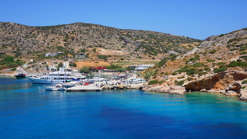
PANO KOUFONISSI With its beautiful people a-tanning, villas projects going up inland and luxury yachts anchored at Porí bay, Páno Koufoníssi is definitely the odd one out among the Mikrés Kykládes the most populated (around 300 souls) and commercialised, separated by a narrow strait from uninhabited Káto Koufoníssi. Áno is a favourite with families owing to gently shelving, protected beaches, and overall a trendy babel: Spaniards, Italians, French, Scandanavians, a few Brits and Americans, and even Greek tour groups from the mainland. If youre looking for a calm bolthole, this isnt one, except in early June or mid-September. While there can be crowds, the island is blissfully free of motor scooters, and theres no bus one walks everywhere, rents a push-bike from one of two outlets (subject to caveats) or uses the taxi-boat service. |
|
THE TOWN (HORA)
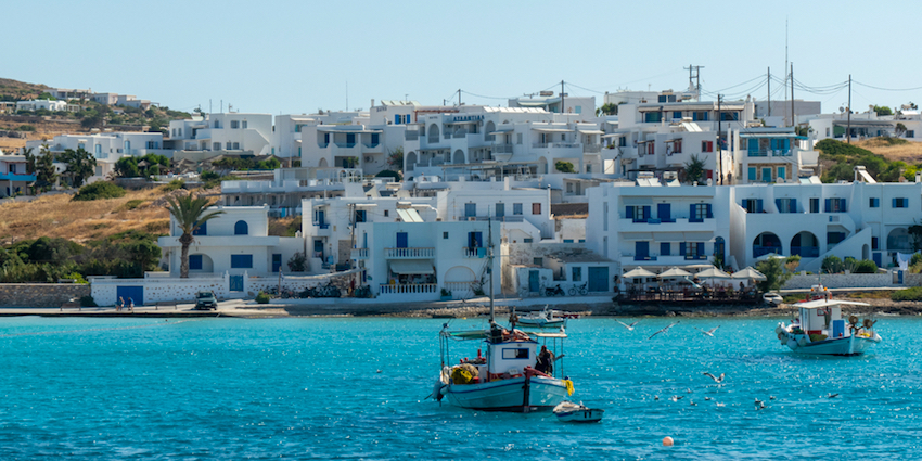
The older quarter just uphill from where you disembark, dominated by Ágios Geórgios church, is home to all shops and most restaurants, while the newer district straggling east of Ámmos for several hundred metres contains most lodging. Their proprietors tend to meet arriving boats in vans, though in cooler weather its not a big deal to walk there if lightly laden. If you just want simple, cheap domátia in the old center, head straight up from the jetty, past the Neo Remezzo taverna, turn right at the pharmacy, then look left. There are a few fancy hotels here as well, though somewhat uninspiringly positioned; for my (or rather, your) money, its better to be well on the way to the beaches, past the eastern edge of town at Pórta cove. Resort Hotel Paradise is aconventional but attractive outfit with pool and sea views. I stayedfurther out, above Fínikas beach, at the mid-range Hotel Anatoli, all units here with verandas facing the knockout view of off-limits-for-archeological-reasons Kéros Island. The Koufonisia Hotel is big enough to host Greek society weddings, and boastsfour-stars. Just 100 metres from Porta Beach, the newly built Portes Houses complex features stylish rooms, and a terrace with views of the Aegean Sea. Incidentally, the island campsite at Harokópou has closed down, though a few tents still sprout free-lance fashion outside its fence. Eating out on Koufoníssi ought to be better than it is I had some uninspiring, overpriced meals best passed over in silence. The most normally priced establishment is ever-popular Karnagio at quayside on Loutró cove, an ouzerí with a good line in píttes, properly grilled fish and rakí from Náxos in season you have to reserve ahead (22850 71694). In the heart of Hóra, Melissa is the oldest taverna on the island, and uniquely in town open for lunch, with good magireftá dishes, seafood and psychedelic chair colours. If your accommodation doesnt do breakfast, an excellent solution is the self-serve beachside restaurant at Fínikas. The top café, with much-sought-after tables in the lane or out on the terrace, is Kohyli, with desserts to die for anything (especially their brownies) can be ordered with a scoop of kaymáki. |
|
THE BEACHES
First notable beach and first stop for the taxi-boats, Fínikas has its aforementioned restaurant, some tamarisks for shelter and an islet for the fit to swim out to. Fanós, at the start of the coastal path, is longer and narrower, while Italída beyond is fatter and tolerates naturism. Beyond lies Platiá Poúnda headland, its margins indented with the fabled pisínes, sculpted inlets which occasionally do support small pools or even sea-caves, and much prized for their overhang shade they will all be spoken for by noon on a summers day. From Italída its about 15 minutes walk around the cape to Porí, the most celebrated beach, with low dunes at the south end and some wind exposure. There are two snack-cafés here, though at my visit only the north-end one was operating, doing a decent job of light lunches and drinks at affordable prices. Finally, there are about 5 daily taxi-boats to Káto Koufoníssi, returning much later to allow folk to patronize the single, reportedly mediocre taverna here. A trail network leads to various swimmable if shadeless coves. I confess I didnt go was too busy staking out a hard-won spot in a pisína near Italída! You can find hotels and rooms in Koufonissi on Booking.com's Koufonissia Page |
|
|
|
SKHINOUSSA (SCHINOUSSA) Halfway between Káto Koufoníssi and Irakliá, jagged-outline Skhinoussa is accordingly popular with yachts and has some spectacular seascapes around even smaller islets to the southwest. This is the one baby Cyclade I havent personally been to; I was put off the idea some years ago by a travel journalist for one of the Athens weekend papers, who claimed the island had been ruined by yacht-borne posers (mostly Greek) slumming it here from Mękonos and driving up prices. I think he possibly got it mixed up with Koufoníssi, and other Greek acquaintances have assured me Skhinoússa is quite normal ambience- and cost-wise. But its true that there is at least one stiffly priced nouvelle taverna (Margarita) and that access to two bays is blocked by locking gates to accommodation grounds or large private villa complexes. Boats dock at Mersíni, from where its a one-kilometre uphill walk (or a van shuttle) to attractive Hóra (aka Panagiá), home to most tourist facilities, including the aforementioned Margarita. There are claimed to be 16 beaches around the islands convoluted perimeter, but some are exposed and/or flotsam-strewn; by consensus the best (and sandiest) are Tsigoúri, closest to Hóra; Alygariá in the far south; Almyrós on the east coast; and Psilí Ámmos in the northeast. None are more than 25 minutes walk from Hóra, mostly along dust-tracks. You can find hotels and rooms in Schinoussa on Booking.com's Schinoussa Page |
|
|
|
IRAKLIA The most southeasterly, and largest, of the inhabited Back Islands (population 120), Irakliá has two substantial villages, and a seasonal minibus service. In the past it was the most traditionally agrarian of these islets, though events have conspired against that. Theres little enough of the excellent local thyme honey in good years and none at all if the spring rains dont come; the vineyards have mostly fallen victim to large flocks of untended, abandoned goats; and squadrons of greedy crows hundreds strong devastate most attempts at agriculture. Under the circumstances, tourism has proved a life-saver, and the locals have remained exceptionally friendly. EU funding has seen to signage and maintenance of some meaty walking trails, numbered from 1 to 8 and best tackled in spring or autumn. Beaches are scarce, and on the functional side. Boats call at Ágios Geórgios, where most tourist facilities are. Its a pleasant settlement draped on either side of a vegetated ravine descending to the smallish but sandy harbour beach; Ágii Anárgyri church at the rear of the village is the only real sight. There are theoretically scooters to rent but I saw nobody using them. Compared to Skhinoússa, theres a fair amount of accommodation see all the choices on Booking.com's Iraklia Page though still scarce in mid-summer. I stayed at the Gavalas familys basic but very quiet Sohoro Rooms (tel 22850 71565), at the start of the path system. Among several tavernas, To Perigiali is ace for fish washed down by good, cheap Parian bulk wine, and one platter of chips feeds two; To Syrma, overlooking the beach, is popular for lunch and quite okay with nice touches like chilled beer mugs, though portions could be bigger. Theres also the long-running Maïstrali, with a view terrace, and the very popular Ypovrihio ouzeri which also does cheap souvláki. WALKING ON IRAKLIA
For now, descend on Trail #3, with great views over Vourkariá bay towards Íos, to the celebrated cave, reached 90 minutes out of the port. Its the right-hand one, not the shallow livestock overhang to the left (the so-called Polyphemos cave); you have to stoop to enter through a low entrance, with cheap throw-rugs provided against the dirt. The interior proves long and narrow, with more stalagmites than stalagtites, a little ikonostásis on one side, and hundreds of flat votive candles left behind. Candles or no, youll need a good flashlight to see much. Returning to the Seládi junction-saddle takes about almost half an hour a stiff climb not for July or August and then its nearly as much again to the sleepy inland village of Páno Horió (Panayía). The main attraction here is the central taverna To Steki tis Annios, with great views from the upper terrace and small-portioned dishes like xinomyzíthra cheese and stuffed goat. Theyre open year-round; youll need to reserve peak season by phoning 22850 71596. The big local panigęri is 28/29 August, including a liturgy in the cave and events in the village; outsiders are most welcome and not considered a nuisance as on some larger islands. From Páno Horió you must road-walk to Livádi or Tourkopígado beaches. BEACHES About 1500m southeast of the port, Irakliás best beach is Livádi, 300m of gently shelving sand, though with some rock in the shallows. The far end is naturist, and you have a reef to swim over. Oddly, theres no taverna, only a single rooms establishment and an official campsite inland (MayOct, French management) rather ignored by knots of rough campers. Overhead is a small medieval castle to explore. Flanking Ágios Geórgios on the southwest is the almost landlocked bay of Voriní Spiliá. Trail #8 goes there, from just beside the villages last, big house with cars and a boat in the fenced front yard. Its about 25 minutes hike down to the bay; what lovely water and sand, and what a mountain of washed-up garbage on the beach that the locals cant be bothered to collect. All it would take is one or two boat trips a month. The third beach is pebbly Tourkopígado, east of Panagía. The summer-only, free minibus ends its run from the port here. Alimniá, beyond Ágios Ioánnis cave, has a sandy bottom and the remains of a crashed World War II plane. You can find Hotels in Iraklia on Booking.com's Iraklia Page |
|
Helpful
Information |
|
RECOMMENDED MAPS
GETTING TO THE MIKRÉS KYKLÁDES All four islands are well served by ferries based on Náxos, Amorgós, Sęros and Piraeus, albeit Donoússa less frequently due to its somewhat inconvenient position off towards Ikaría. From Piraeus, Blue Star Ferries call most of the year several evenings weekly (leaving at 5.30pm), via Páros, Náxos sometimes Sęros and arriving at Donoússa (2 to 3 weekly) or the other three (2 to 3 weekly) between 12.30 and 1.20 am pre-book your room and proprietors will fetch you. The same boat continues to Amorgós and Astypálea before turning around immediately at 4am, so thats the Dodecanese connection. Twice a week, a conventional ferry leaves Sęros at 7am, calling at Páros and Náxos before cycling through all four islets. Once or twice weekly a high-speed catamaran stops at Koufoníssi, but these are expensive and tend to call absolutely everywhere in the Cyclades before ending up back at Sęros or Piraeus. Finally, the little Skopelitis Express leaves Náxos most days between 2 & 3pm, bound for most of the Back Islands (but Donoússa only 3 times weekly), en route to Amorgós, whence it returns early the next morning. Its cheap and reliable, but slow and nicknamed the skylopníkhtis (dog-drowner) by the unkind owing to a buckety ride in rough seas, more common than not hereabouts. Arrive in a big boat if you can, or just use Skopelitis for short inter-island hops within the group.
There are few travel agencies that can assist you with booking these islands but times change and it is worth asking a recommended travel agency in Athens. See www.athensguide.com/agency.html Marc Dubin first visited Greece in 1978, fell in love with it, and returned almost yearly until he began living much of the time on Samos in 1989. He has written for numerous travel publishers notably Rough Guides and Insight Guides and on a variety of topics ranging from renovating old Greek houses and Greek cuisine to back-country trekking and Greek music. Marc has also compiled two CDs for World Music Network, Rough Guide to Rebetika and Rough Guide to Greek Café. He is an accomplished photographer and most of the pictures accompanying the articles on greecetravel.com are his. (You can click on his photos above to see them full size.) To contact Marc with offers of writing jobs or praise you can e-mail him through matt@greecetravel.com |
 I first heard
about the Mikrés Kykládes
(Little Cyclades, alias the Back Islands for
being behind Náxos) from my rooms proprietor
on
I first heard
about the Mikrés Kykládes
(Little Cyclades, alias the Back Islands for
being behind Náxos) from my rooms proprietor
on 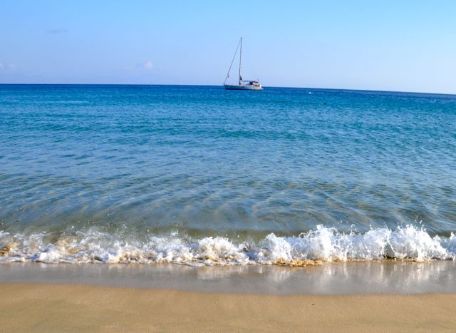 There are actually
about a dozen baby Cyclades, but only four are
inhabited in our times: Donoússa, Páno
Koufoníssi, Skhinoússa, and
Irakliá. They are strikingly
different from one another, each with their
particular clientele though none now rank as
undiscovered, and all of them, given limited
accommodation, are no-go areas from mid-July to
September 1 unless you have a rooms reservation
or are happy to camp out. Athens agencies are
unlikely to be able to help with advance lodging
reservations, except on Páno Koufoníssi and
Skhnioússa which have some luxury complexes. Páno
Koufoníssi also has the best beaches, with
Donoússa not far behind; Irakliá has the best
walking, with again Donoússa running second.
Accommodation can be on the cheap side, but
dining out is definitely not little islands do
not mean little prices. While all four have a
bank ATM apiece, best not rely on these but come
equipped with plenty of cash.
There are actually
about a dozen baby Cyclades, but only four are
inhabited in our times: Donoússa, Páno
Koufoníssi, Skhinoússa, and
Irakliá. They are strikingly
different from one another, each with their
particular clientele though none now rank as
undiscovered, and all of them, given limited
accommodation, are no-go areas from mid-July to
September 1 unless you have a rooms reservation
or are happy to camp out. Athens agencies are
unlikely to be able to help with advance lodging
reservations, except on Páno Koufoníssi and
Skhnioússa which have some luxury complexes. Páno
Koufoníssi also has the best beaches, with
Donoússa not far behind; Irakliá has the best
walking, with again Donoússa running second.
Accommodation can be on the cheap side, but
dining out is definitely not little islands do
not mean little prices. While all four have a
bank ATM apiece, best not rely on these but come
equipped with plenty of cash.
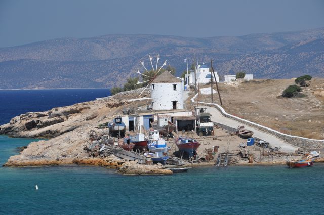
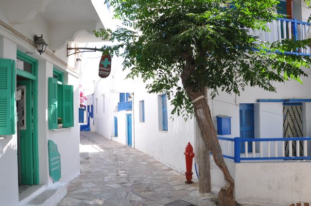
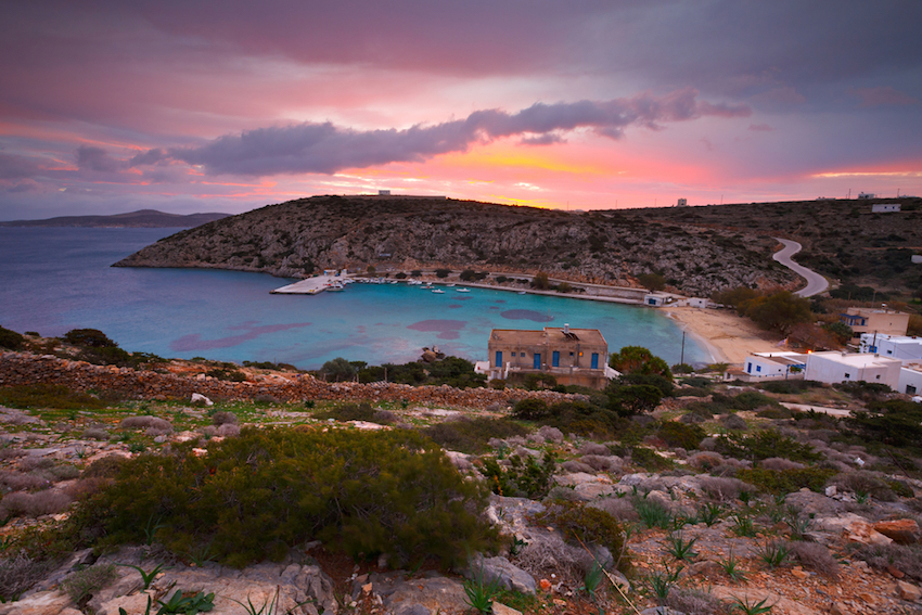
 Stavrós, home to most of
Donoússas population of 160, brackets the
islands largest if not best beach, popular with
families (so no nudism or camping). The only
particular sight is the church (festival 1314
September). All island accommodation is here,
which doesnt amount to much more than 100 beds.
Among the better ones is To Iliovasilema (tel
22850 51570, www.iliovasilema-studios.gr) on the
bays east flank. Eating out, best of the three
full-service tavernas above the yacht quay is To
Meltemi, though others prefer Captain George.The
in-house diner of To Iliovasilema (May 10Sept 1
only) is probably your best bet both value- and
quality-wise. Shops are surprisingly poor but
there is a greengrocer's shop sellingfruit and
vegetables.
Stavrós, home to most of
Donoússas population of 160, brackets the
islands largest if not best beach, popular with
families (so no nudism or camping). The only
particular sight is the church (festival 1314
September). All island accommodation is here,
which doesnt amount to much more than 100 beds.
Among the better ones is To Iliovasilema (tel
22850 51570, www.iliovasilema-studios.gr) on the
bays east flank. Eating out, best of the three
full-service tavernas above the yacht quay is To
Meltemi, though others prefer Captain George.The
in-house diner of To Iliovasilema (May 10Sept 1
only) is probably your best bet both value- and
quality-wise. Shops are surprisingly poor but
there is a greengrocer's shop sellingfruit and
vegetables.
 Taxi-boats
to/from Stavrós are only reliable in July and
August, so you should count on walking to/from
the beaches otherwise.
Taxi-boats
to/from Stavrós are only reliable in July and
August, so you should count on walking to/from
the beaches otherwise.
 Remedies for
the damage to the island trail system are just
beginning most notably dubbing the path to
tongue-twistingly named Kalotarítissa in the far
north as Route #1. Follow red-and-white markers
out of Stavrós to the ring road and a builders
yard where the old trail resumes in earnest along
the west side of a ravine. About half an hour out
of town youre forced to adopt the newer track,
though true path resumes after 15 minutes just
before the summit of the route, with dramatic
overlooks of your destination and soon, as the
path describes a gently descending arc, spindly
Asprokávos to the west. Getting to Kalotarítissa,
1hr 15min from Stavrós, is definitely more than
half the fun its ten houses and three shadeless
nearby coves are hardly compelling, ditto its
single overpriced taverna; try and hold out for
lunch until reaching Mersíni.
Remedies for
the damage to the island trail system are just
beginning most notably dubbing the path to
tongue-twistingly named Kalotarítissa in the far
north as Route #1. Follow red-and-white markers
out of Stavrós to the ring road and a builders
yard where the old trail resumes in earnest along
the west side of a ravine. About half an hour out
of town youre forced to adopt the newer track,
though true path resumes after 15 minutes just
before the summit of the route, with dramatic
overlooks of your destination and soon, as the
path describes a gently descending arc, spindly
Asprokávos to the west. Getting to Kalotarítissa,
1hr 15min from Stavrós, is definitely more than
half the fun its ten houses and three shadeless
nearby coves are hardly compelling, ditto its
single overpriced taverna; try and hold out for
lunch until reaching Mersíni.
 From the
environs of Mersínis spring, the path down to
Livádi revamped in 2010 is pretty unmissable
and somewhat pointlessly labelled as Path #3. The
onward bit from Livádi to Kédros is trickier but
perfectly feasible. At the west end of the beach,
follow the cairned trail uphill 10 minutes to a
stone wall, bear right for at most 20 yards, and
then left over the brow of the hill, onto what
quickly becomes a corniche route high above the
Aegean. Soon this broadensinto a track which
skirts a crumbled farmstead and curls around a
canyon to just touch the asphalt road. Leave this
almost immediately at another cairn to traverse a
neck of land dipping gradually towards Káto
Męlos, over terraces and through a fence-gate to
intersect the old contour path hugging the coast.
Bear west to follow this across the heads of two
inlets to end up at the Kédros café in under an
hour from Livádi. Time for a Náxo-distilled rakí
(psiméni with herbs and honey in the cooler
seasons) and maybe a final swim before the tramp
back to town.
From the
environs of Mersínis spring, the path down to
Livádi revamped in 2010 is pretty unmissable
and somewhat pointlessly labelled as Path #3. The
onward bit from Livádi to Kédros is trickier but
perfectly feasible. At the west end of the beach,
follow the cairned trail uphill 10 minutes to a
stone wall, bear right for at most 20 yards, and
then left over the brow of the hill, onto what
quickly becomes a corniche route high above the
Aegean. Soon this broadensinto a track which
skirts a crumbled farmstead and curls around a
canyon to just touch the asphalt road. Leave this
almost immediately at another cairn to traverse a
neck of land dipping gradually towards Káto
Męlos, over terraces and through a fence-gate to
intersect the old contour path hugging the coast.
Bear west to follow this across the heads of two
inlets to end up at the Kédros café in under an
hour from Livádi. Time for a Náxo-distilled rakí
(psiméni with herbs and honey in the cooler
seasons) and maybe a final swim before the tramp
back to town.
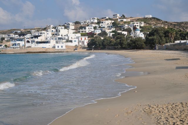
 Like Stavrós on Donoússa
(albeit on a much bigger scale), the Hóra is
divided by hard-packed Ámmos beach, with bathers
segregated from the many anchored fishing boats,
which also berth at Parianoú bay in the far west
though an energetic fishing fleet is no
guarantee of seafood on your taverna platter.
Still, theres an active boatyard above Loutró
cove flanking town to the west, surmounted by a
windmill thats become Koufoníssis
trademark.
Like Stavrós on Donoússa
(albeit on a much bigger scale), the Hóra is
divided by hard-packed Ámmos beach, with bathers
segregated from the many anchored fishing boats,
which also berth at Parianoú bay in the far west
though an energetic fishing fleet is no
guarantee of seafood on your taverna platter.
Still, theres an active boatyard above Loutró
cove flanking town to the west, surmounted by a
windmill thats become Koufoníssis
trademark.
 All the fabled beaches
line the more sheltered southeast coast, facing
Kéros. In season, about 4 daily taxi-boats call
between noon and dusk from the base of the town
jetty. Fanós marks the end of the paved coastal
road; if you try to continue by bike you face a
punishing hill between here and Porí, or a
hazardous, tire-risking trajectory along the
onward coastal path. Few of the island beaches
have any significant shade the foresightful
come with pop-up shelters, which can be bought in
Athens central bazaar.
All the fabled beaches
line the more sheltered southeast coast, facing
Kéros. In season, about 4 daily taxi-boats call
between noon and dusk from the base of the town
jetty. Fanós marks the end of the paved coastal
road; if you try to continue by bike you face a
punishing hill between here and Porí, or a
hazardous, tire-risking trajectory along the
onward coastal path. Few of the island beaches
have any significant shade the foresightful
come with pop-up shelters, which can be bought in
Athens central bazaar.
 The best hike crosses Irakliá to the cave of Ágios Ioánnis, largest in
the Cyclades; head out of Ágios Geórgios
following Trail #7 markers. Some 10 minutes
along, this becomes a fine, broad kalderími,
clearly once the islands major thoroughfare.
Turn hard right upon reaching a cluster of
cistern-wells, where the lone local cowherd may
be watering his charges, and climb slightly to
the nine houses of Ágios Athanásios hamlet, with
just three inhabited; go past the last one to
find the start of onward Trail #4. Just over an
hour along, this reaches the high point of the
route with great views over Náxos and other Back
Islands, a major trail junction indicated by a
veritable forest of signs.
The best hike crosses Irakliá to the cave of Ágios Ioánnis, largest in
the Cyclades; head out of Ágios Geórgios
following Trail #7 markers. Some 10 minutes
along, this becomes a fine, broad kalderími,
clearly once the islands major thoroughfare.
Turn hard right upon reaching a cluster of
cistern-wells, where the lone local cowherd may
be watering his charges, and climb slightly to
the nine houses of Ágios Athanásios hamlet, with
just three inhabited; go past the last one to
find the start of onward Trail #4. Just over an
hour along, this reaches the high point of the
route with great views over Náxos and other Back
Islands, a major trail junction indicated by a
veritable forest of signs.
 Theres just one
commercial map available, at 1:25,000 scale, for
all four islands, issued by Terrain
(www.terrainmaps.gr). Coverage ranges from
tolerable for Irakliá to poor on Donoússa, where
a wall-mounted placard-map just below the bakery
gives a far better idea of the surviving trail
network. An accurate topographical placard map of
Irakliá is also posted at several points on the
island, but again its unavailable for
distribution click on our photo of it to
enlarge and print out.
Theres just one
commercial map available, at 1:25,000 scale, for
all four islands, issued by Terrain
(www.terrainmaps.gr). Coverage ranges from
tolerable for Irakliá to poor on Donoússa, where
a wall-mounted placard-map just below the bakery
gives a far better idea of the surviving trail
network. An accurate topographical placard map of
Irakliá is also posted at several points on the
island, but again its unavailable for
distribution click on our photo of it to
enlarge and print out.


Join Matt Barrett's Greece Travel Guides Group on Facebook for comments, photos and other fun stuff. If you need assistance or have any questions e-mail me. If you enjoy this website please share it with your friends on Facebook. If you are appreciative of all the free information you get on my websites you can send a donation through Paypal